Climate of Mauritius: From hail to no snow

The first thing to note here is that there is a difference between the words climate and weather. While people use these two words interchangeably, they, in fact, mean different things.
Weather refers to atmospheric conditions over short periods of time, from daily to minutely. As it is quite common in Mauritius, the day may seem bright and sunny and then suddenly there’s a crash of rain and it gets back to being sunny again. This is what we call weather.
Climate refers to atmospheric conditions over a long period of time, for instance, the trend during the past 10 years. It takes into consideration the amount of rainfall, wind speed, hail, snow, temperature, humidity, sunshine amongst others for generally a 30 years’ period. Here we are going to consider the general climatic trends for Mauritius.
What influences the climate of Mauritius?
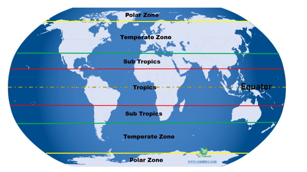
The island of Mauritius is located at latitude 20⁰ S and longitude 57⁰ E. It thus falls into the subtropical climate in relation to the equator. This location infers a maritime and moderately humid subtropical climate. Since the island is in the middle of the ocean, it is greatly influenced by prevailing oceanic conditions.

Mauritius is small in size with low peaks; the climate is generally influenced by the movement of winds from place to place and the degree to which different regions are sheltered from or exposed to these winds.
Seasons in Mauritius
There are two seasons: summer and winter, each spanning over a 6 months’ period. Summer lasts from November to April while winter lasts from May to October. February is the hottest month with an average temperature of 27⁰C on the coasts and 22⁰C on the central plateau. The coolest month is July with an average temperature of 22⁰C on the coasts and 16⁰C on the uplands. The movement of winds over the low altitude oceans generates cyclones in summer and anticyclones in winter.
So why is there no snow in Mauritius?
For snow to form, freezing temperatures below 0⁰C are needed. Since we are located in the subtropics, the lowest temperatures in Mauritius can reach 15⁰C on the central plateau during the harshest nights. So they are not low enough to form snow. High altitudes also encourage snow formation. The higher the summits the easier it is for snow formation like mountain caps on lanky mountains. However, here, the highest peak reaches only 828 m which again is too low for snow to form.
Hail in Mauritius
Hail is formed when rising air pulls water droplets high enough that it freezes into a ball of snow. More accurately, hail is the result of rising updraft meeting with super cooled water droplets (water droplets surrounded by freezing air). A tiny ice crystal will form which will eventually enlarge with the super cooled water droplets to form hail rocks.
On rare occasions during summer, hail can fall on the island; the condition has been reported in many areas like Curepipe, Piton, Surinam to name a few. The fast change in temperature from hot, evaporating, low ground air to the cold upper layers produces the phenomenon.
Rainfall in Mauritius
The relief of the island plays a very important role in the distribution of rainfall. The trade winds blow from the south-east and thus distribute clouds and rainfall. The eastern and southern coasts are quite humid since they are right in the pathway of the moving winds. From there, elevated peaks influence the amount of rainfall coming to a particular region. The north and west are protected from the winds by the central plateau, so they receive less rainfall. The west lies still lower on the ground and so receives even less rainfall. The mean annual rainfall on the uplands is 4000mm, 900mm on the west coast and 2000mm on the east coast.
There is a seasonal dry and wet period. The dry period is from May to October and the wet period is from November to April. In the past, wet seasons stimulated great landslides when the amount of rainfall recorded was in the 1300mm. Excess of rainwater from underground was the causative agent. Those landslides have decreased considerably over the years due to the cutback on annual rainfall; today, occasionally materials slide down mountains during intense rainfall.
Meaning of a solar halo
There are times when a beautiful halo forms around the sun. This phenomenon, also called the 22⁰ halo because of its radius around the sun, usually announces the coming of rain. Basically, it is formed when the weather is good and there are high thin clouds in the sky. These clouds are made up of tiny ice crystals which reflect and refract sun rays in such a way as to produce a circle or halo around the sun. The inner edge is usually sharper and red in color while the outer band is thicker and white. This halo can also form around the moon. There is a weather saying that goes ‘if there is a halo around the sun or moon, then we can all expect rain quite soon.’ Next time you see a halo around the sun, you know what it means!

Pingback: Have Sippy Will Travel
Pingback: Mauritius: Geography, History, Travel and Top Attractions - Yo Nature
Pingback: Sustainable tourism in Mauritius: Measures in place - Yo Nature
Pingback: Mauritius Oil Spill: Japanese MV Wakashio wrecks on reef - Yo Nature
Pingback: Sea level rise Mauritius: Relocation as a prospective solution - Yo Nature
Pingback: 10 common medicinal plants in Mauritius - Yo Nature
Pingback: Biodiversity (Flora and Fauna) of Mauritius - Yo Nature
Pingback: Extreme Weather: Flash floods become frequent in Mauritius - Yo Nature